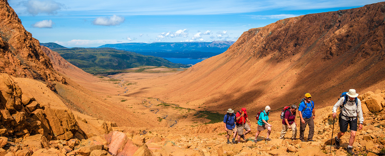
Gros Morne National Park, and the remarkable Tablelands, is a trip back in ancient history
Imagine a place where you can hike to the highest point on land to reach what once was the bottom of the ocean. There, the Earth’s mantle and crust are on display in one of the most spectacular expressions of its kind anywhere in the world. The mantle is the layer that lies between the planet’s super-heated core and its thin outer layer, the crust, which supports all life on Earth.
“Geologists have a special name for these remarkable examples of oceanic crust and mantle that now sit at the surface of the Earth,” says Dr. Andrew (Andy) Kerr, an earth scientist at Memorial University of Newfoundland. “We call them ophiolites, and the spectacular red-and-brown mountains that surround the Bay of Islands are examples.”
The most well-known examples are the Tablelands, arguably the most important geological feature of Gros Morne National Park and the basis for its UNESCO World Heritage Site designation. The park is said to reach so far back in time that its lands heard the echo of the “Big Bang.” That’s because hidden under the barren, burnt umber rubble is the story of continents colliding and forming the Appalachian Mountains and the Long Range Mountains of Newfoundland along the collision line.
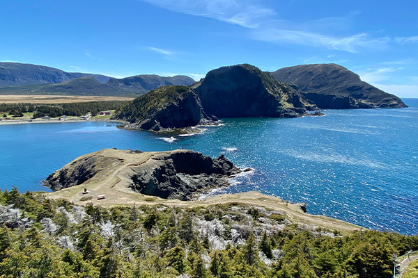
But what many tourists and locals don’t know is that the same defining elements of the Tablelands extend along the west coast to the Bay of Islands. A drive around the region reveals one hidden geological gem after another—from the pillow lavas of Bottle Cove, to the ancient oceanic crusts and mantle rocks of the Lewis Hills, to the highest peak on the island portion of Newfoundland and Labrador, Cabox. This peak is pronounced “k-box” and is thought to reference the Portuguese word cabos for capes, the first visible landmark for seafarers approaching the Bay of Islands from the Gulf of St. Lawrence.
“I commonly find that students aren’t aware of aspects of the landscape,” says Dr. Norm Catto, a geography professor at Memorial University of Newfoundland. “There are several areas with exposed ophiolite in western Newfoundland, in addition to the four largest areas.”
Cabox Aspiring Geopark
Perhaps surprisingly, the Tablelands are the smallest of these four areas, which also comprise the Lewis Hills, Blow Me Down Mountains, and North Arm Hills/Gregory Mountains in western Newfoundland. What the ranges share are a story of Earth’s incredible history, tucked within the rock in people’s backyards, down and around the bay.
“The modern landscapes are fashioned from a complex ‘architecture’ of rock formations,” says Kerr, who also works for the Geological Association of Canada as the scientific editor of Geoscience Canada. “These also tell a story, but a much older one, dating back to at least 500 million years ago. This story relates to the concepts of continental drift and plate tectonics, and western Newfoundland was a very influential place in establishing these ideas and demonstrating that modern observations of the dynamic Earth could also be applied deep into the geological past.”
In Kerr’s explanation of that history, he begins, “once upon a time what is now the west coast of Newfoundland was part of an ancient ‘continental shelf.’ It probably looked more like the continental shelf off Florida—shallow warm waters, with limestones and reefs. But this ancient continental shelf was doomed. The continent on which it existed was about to collide with some chains of volcanic islands in an adjoining ocean basin.”
Think of that ocean basin as a precursor to our modern Atlantic Ocean, says Kerr. “We call this vanished ocean Iapetus (after the father of Atlantis in mythology). In plate tectonics, continents move around, and oceans are transient features, that are created and destroyed over immense time periods. Eventually, the ancient continental shelf was overridden by the volcanic islands, and all the deeper parts of the continental shelf were squished in between. These rock formations were then transported hundreds of kilometres across the continental shelf so that they sat on top of it.”
The end result provides a striking example of the mobility of the ancient Earth, and its recognition some 50 years
ago was an important step in geological thinking, says Kerr. That’s when the work of Harold “Hank” Williams—no, not that Hank Williams, although he is a banjo-playing, Newfoundland-born geologist whose name is legendary in geological circles around the globe—helped prove that continents had collided, creating the mountain chains of the Appalachian mountains. Williams’ work popularized plate tectonics and continental drift.
“Modern mountain belts such as the Alps and the Himalayas are located in places where continental plates are colliding. Ancient mountain belts like the Appalachians, of which western Newfoundland is a part, are places where this happened hundreds of millions of years ago,” says Kerr.
Another reason the region is so appealing to visitors are its fjords and picturesque coastal communities, created largely during and following the last of several ice ages, which ended some 12,000 years ago. That’s what carved the fiords of the Bay of Islands as well as those in Gros Morne National Park (Bonne Bay and Western Brook Pond). Given the region’s extensive geological heritage, a group has come together in the Bay of Islands in hopes of garnering its own UNESCO designation as a Global GeoPark.
“At the heart of western Newfoundland is a land deserving of a title to match its significance on Earth,” says Chief Brendan Mitchell of Qalipu First Nation. Qalipu is a Mi’kmaq First Nation whose membership is spread across 67 traditional Newfoundland Mi’kmaq communities and abroad, making it one of the largest First Nation groups in Canada. Newfoundland is part of the traditional Mi’kmaq Nation whose territory extends from Quebec through the Maritime Provinces and into Newfoundland.
Cabox Aspiring Geopark—as the Bay of Islands group calls itself—is working with Qalipu as well as municipalities along the Bay of Islands, to host its second annual Cabox Art and Adventure Festival this year. The festival combines landscape and visual arts (workshops, installations, etc.) with boat tours and hiking, allowing festivalgoers an opportunity to take in the geological marvels in their own backyards.