The trail is a classic meeting of ocean and land, winding through wind-swept spruce and fir forests, bogs and open grassy meadows. There are great views of Port Rexton and Trinity.
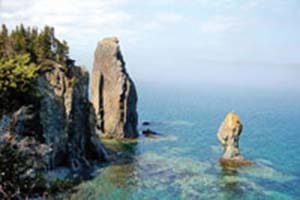
{sidebar id=15} But it’s the coastline that will stop you in your tracks, with its memorable beaches and sea stacks (eroded rock formations)—the latter having names such as Music Box because of the sound produced when the wind blows.
The 5.3 kilometre trail is rated easy to moderate (there’s an optional, more challenging four-km loop for “serious” hikers.) Many times trails are part of a vast network of foot and cart paths from years gone by—retracing four centuries of settlement and subsistence, where early pioneers gathered berries, hunted seabirds and travelled to neighbouring communities.
On our hike in early June we saw several icebergs, including a magnificent one just in front of the lighthouse in Trinity. When I stopped at a lookout to take pictures of the berg I noticed abundant moose droppings, realizing that moose must like a good view as well!
Eco-friendly hiking tips:
Don’t feed the foxes, and be sure to watch your step near fox holes.
If you are hiking this trail after a rain, wear waterproof shoes.
Pack a lunch or a snack and plan to rest at the grassy meadows on the headland.
GPS coordinates
Trail starts and ends at Trinity East (next to church), off Route 230
48º 22.746’ N
53º 20.398’W